A simple trial, a video made through PowerPoint. The audio is irrelevant. http://youtu.be/gy6O56UiHxc
YouTube video
5 Replies
A simple trial, a video made through PowerPoint. The audio is irrelevant. http://youtu.be/gy6O56UiHxc
This, an output from a simple data upload to ArcGIS
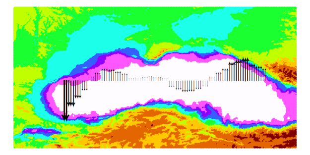
GIS featured heavily this week, top, tail and middle. Having introduced GIS to the postgraduate surveyors in Term 1, I found I’d covered my basics by their third session on Monday and I was left wondering what to do for today. Fortunately, I’d been asked to help display tidal stream arrows for the Black Sea to a colleague the previous week and I was able to use his data as an exercise today. Asking those who were confident to produce an image similar to my own, I then worked through the data with those less sure and … after a fight (as per normal with ArcGIS) … we managed to get slim arrows, scaled by tidal stream strength, oriented by a simple N or S direction across a colour coded topographic/ bathymetric layer of the Black Sea. If I manage to load it, the image will appear associated with this blog.
The middle GIS? Well that was a viva where the doctoral student produced some individual manipulation of computer-modelled tide and wave-induced water values to simulate inundation of an estuary. Interesting stuff.
This week’s been a focus of planning by undergraduates and MSc student for their Projects and Dissertations, with the students working up their plans and discussing their viability. Topics have included building a GIS of Plymouth Sound, tunnel surveying, using those credit card-sized computers (Raspberry Pi) as a data logging system, replacing a side scan sonar with a multi beam echo sounder, addressing pipe laying in Nigeria and tidal studies in the local river – the Tamar. There’s more thinking, reading and decision making yet until we’re all clear on what’s to be studied.
So lots of other activities: writing references; contributing to discussions on staffing, proposing changes to the delivery of the degree and last night an excellent evening talk by one of my graduates … He works out of Norway and has contributed to the investigation of a WWII German submarine which is lying on the seabed complete with mercury pollution. Now that’s an interesting study worth a blog.
The scope and level of courses in hydrographic surveying have changed over the years. Currently we offer one 3 year undergraduate (Full time) and one 1 year postgraduate (Full time) courses – with part time options available. In other years we have offered short courses, an HND and a second postgraduate course – an MRes Geomatics. You can also study at doctorate level.
We are approaching a re-write of our degrees and there will be significant change to both extant taught courses. We expect to have them ready by September 2014 for a September 2015 start. We will have blocked modules in the First Year (aka Stage 1) though, conversely, we’re dropping the blocked teaching at Masters level to deliver over the whole of each semester.
